Free Maps
These are my free maps covering the Shrewsbury and Newport Canals.
Download these free maps (from the links at the end) to see how good my maps are, and to check you can install them on your device(s).
All the maps in my range are produced in this clear style showing the information you need for cruising, and helping with walking or cycling too.
They are all available to download in a choice of Acrobat (pdf) and Memory‑Map (qct) formats.
Clear Maps
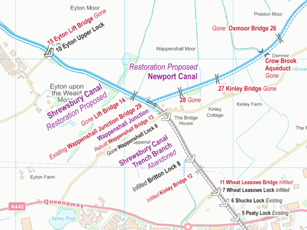
Clear presentation shows the Locks, bridges, and aqueducts etc. superimposed on an Ordnance Survey (OS) background map. Download the key to see the features which appear on the maps.
Route Covered
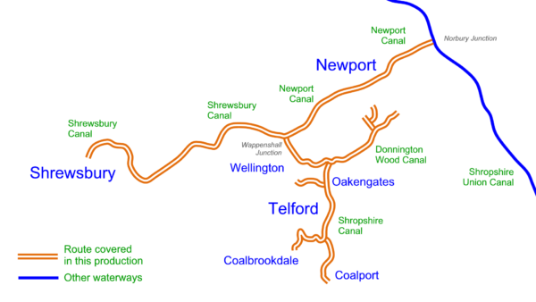
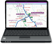
My free Shrewsbury and Newport Canals maps cover the route shown in orange including:-
- Newport Canal
- Shrewsbury Canal
- Humber Branch
- Trench Branch
- Wombridge Canal
- Donnington Wood Canal
- Lilleshall Arm
- Lilleshall Branch
- Pitchcroft Branch
- Shropshire Canal
- Coalbrookdale Branch (or Horsehay Branch)
- Ketley Canal
Map Formats
The Shrewsbury and Newport Canals Maps are available in a choice of two formats:-
The Acrobat (pdf) map includes 13 pages of maps plus 5 cover pages. These can be viewed on screen a page at a time.
The pages are sized for printing A4, or A5 if your eyesight is good enough.
This map can be used on computers, laptops, phones and tablets with Acrobat Reader (or equivalent) software or app installed.
The Memory-Map (qct) map has the same map pages joined into one scrollable and zoomable map.
This map works on Android, iPhone/iPad, Windows and Mac with Memory‑Map (or equivalent) software or app installed, and the classic map compatibility option enabled.
Installing
Please read more about installing each of the map formats, and the software or apps you will need to install:-
Licensing and Copyright
The maps are licenced and free for personal use. Business licences are available on request.
Copyright in the background maps is held by Ordnance Survey. Copyright in all other work is held by Waterway Routes. The maps should not be copied or distributed without permission except for the limited circumstances permitted by law.
Alternatives
The Shrewsbury and Newport Canals Maps also appears in:-
- England & Wales Map which includes all the Waterway Routes maps joined into one large map which is cheaper than buying the maps individually.
Downloading
Please use these links to download and save my free Shrewsbury and Newport Canals Maps:-
- Shrewsbury and Newport Canals Map in Acrobat (pdf) format
- Shrewsbury and Newport Canals Map in Memory‑Map (qct) format
The file sizes to download are approximately:
- Acrobat (pdf) version 16Mb.
- Memory‑Map (qct) 10Mb



Hello Paul
Thank you very much for these fantastic maps, they are so clear and detailed, and a wonderful resource for those of us who walk the old towpaths of disused canals which are now parts of our local footpath network around Telford and Shropshire, as well as the towpaths of those canals still in water. Many walkers like our Ramblers Group are interested in the details of places they pass through. I wonder if wearing my volunteer hat for The Friends of the Telford T50 50 Mile Trail I could email you directly about referring to these maps in a guidebook we are writing about our new Coronation Walks so links and credits are accurate. many of these walks to cross and follow parts of the now disused canals which the Trust is busy restoring. If you could reply to my email we could correspond directly perhaps? Coincidentally I use the same raster OS maps as you do as base maps for our waymarked trails, they are great aren’t they for writing information over, but it takes a lot of time to do this as clearly as you have done, hats off to you, a brilliant job! All our projects are ‘not for profit’, any income from book sales goes towards improving our path networks and developing new marked routes, we are all local volunteers, wanting to encourage people to explore the history and heritage on their doorstep.
I’m sure we can work together. I will email you to discuss this directly.
Hello, thanks for this mapping. Very thorough and the network of old canals so fascinating.
Just to let you know of a typo for a future edit. On pdf map SAN06 you have written ‘Kinnetrsley Drive Aquaduct’ instead of ‘Kynnersley …’. Ref OS Explorer map 242 Square SJ6816.
Thanks.
I’m pleased you enjoy my maps. Thanks for pointing out the typo, that will be corrected on the next of the monthly updates, published around the middle of every month.
I am a member of Shrewsbury & Newport Canals Trust..
There is a link to your excellent free map collection of our local canal on our website (https://sncanal.org.uk), but it is very convoluted to get to it from the Waterway Routes home page provided. Could you let me know if a simple direct link is possible, that we may provide on the SNCANAL website?
Thank you.
Martyn Vincent
You can link directly to https://www.waterwayroutes.co.uk/blog/32m3/
Please DO NOT link directly to the .pdf and .qct map files as these names change from time to time.
Absolutely brilliant. Thanks for doing the work.
We were in Shrewsbury yesterday and saw a pub called’ The Canal Tavern’. We had no idea there was a canal there. We can now try and trace, and walk, the towpath.
Alan: Thank you for your comment, I’m pleased you like my maps.
Please spread the news about how good they are.
Beautiful maps. My father’s family came from Longdon-on-Tern and I have always hoped the iron aqueduct would one day be restored for navigation so the proposals are very encouraging. Can you check the spelling on map 2 of the PDF – it is saying ‘Longton Aqueduct’ rather than ‘Longdon’. Best wishes. SD.
Simon: I’m pleased you like my maps.
I’ve corrected that typo on the master map and it will appear correctly on the published maps from the monthly update in September 2019.
Thank you for letting me know.