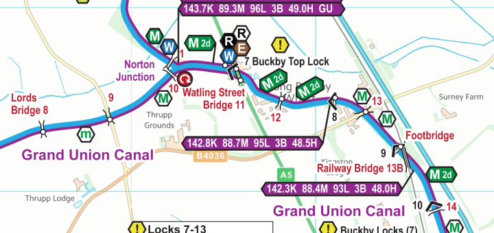
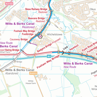
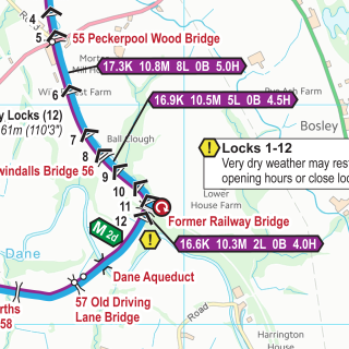
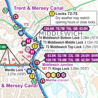
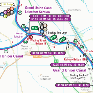
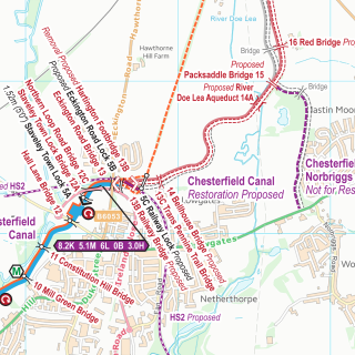
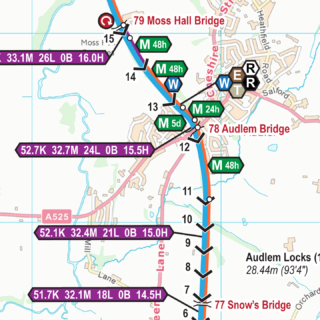
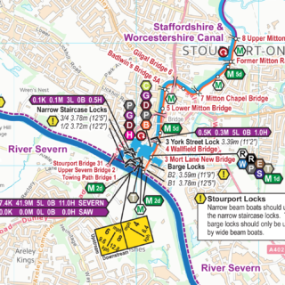
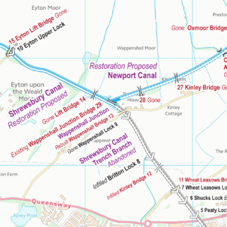
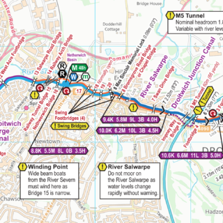
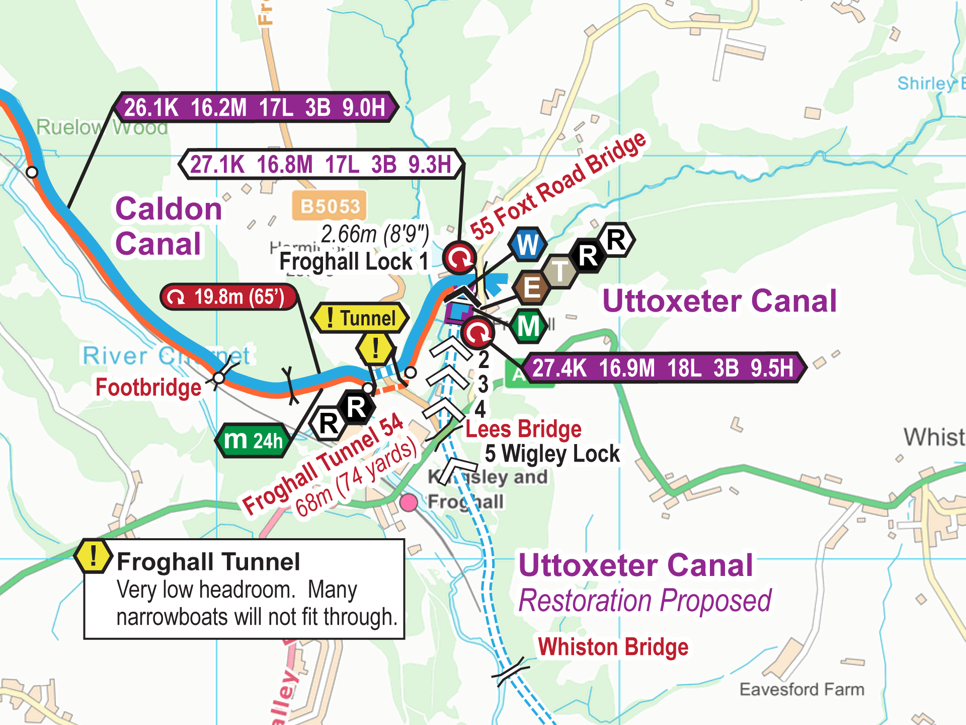
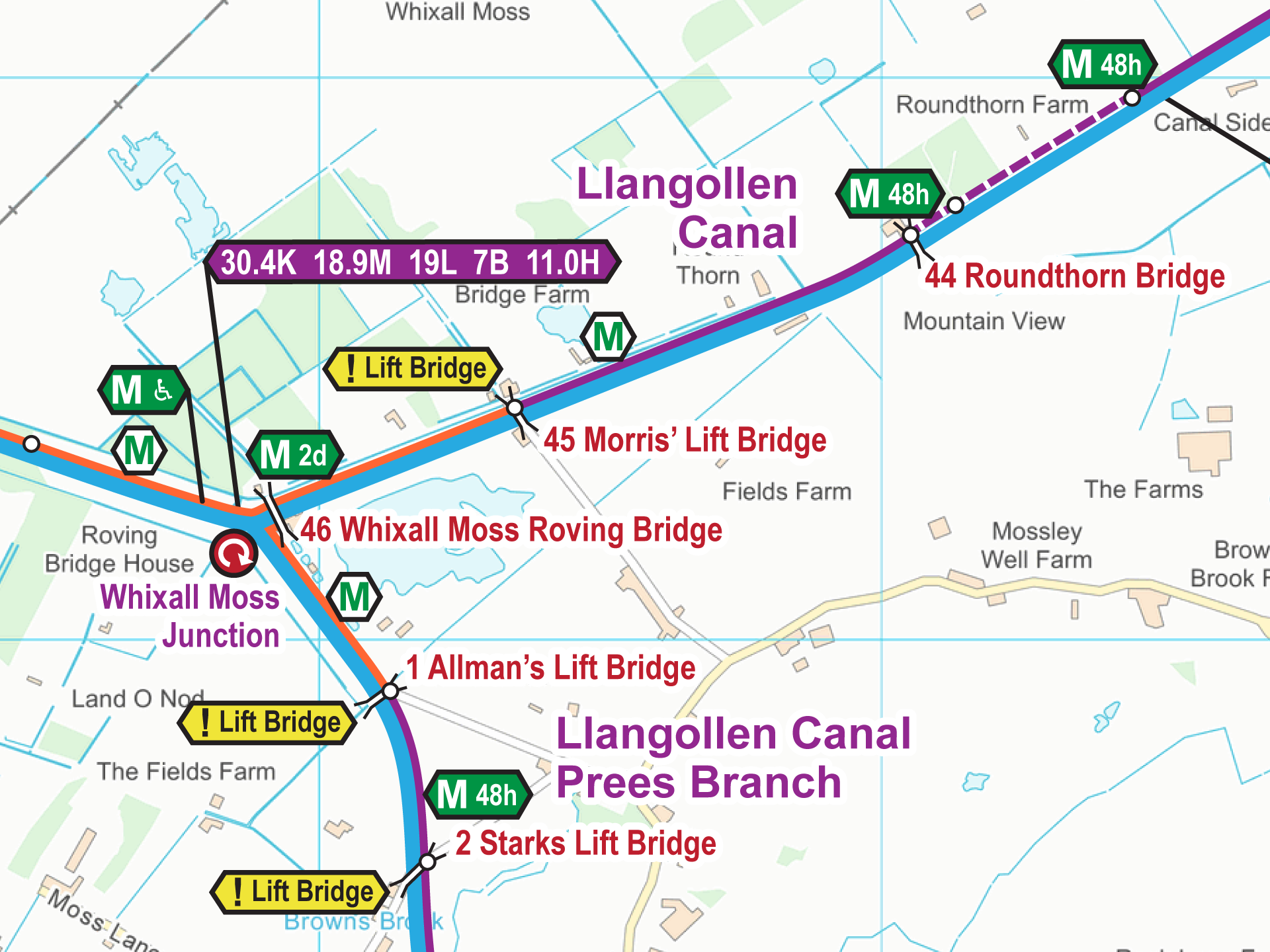
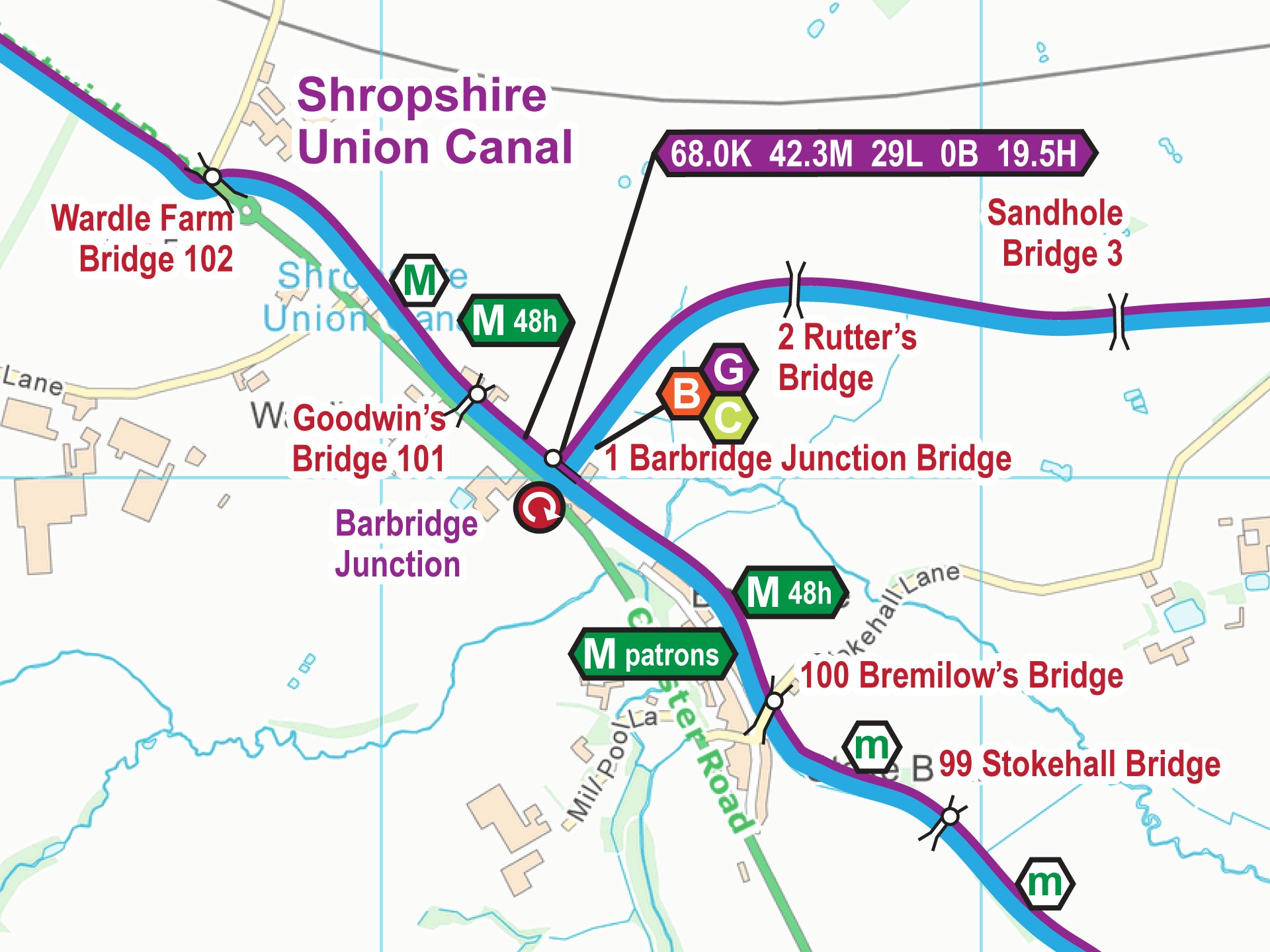
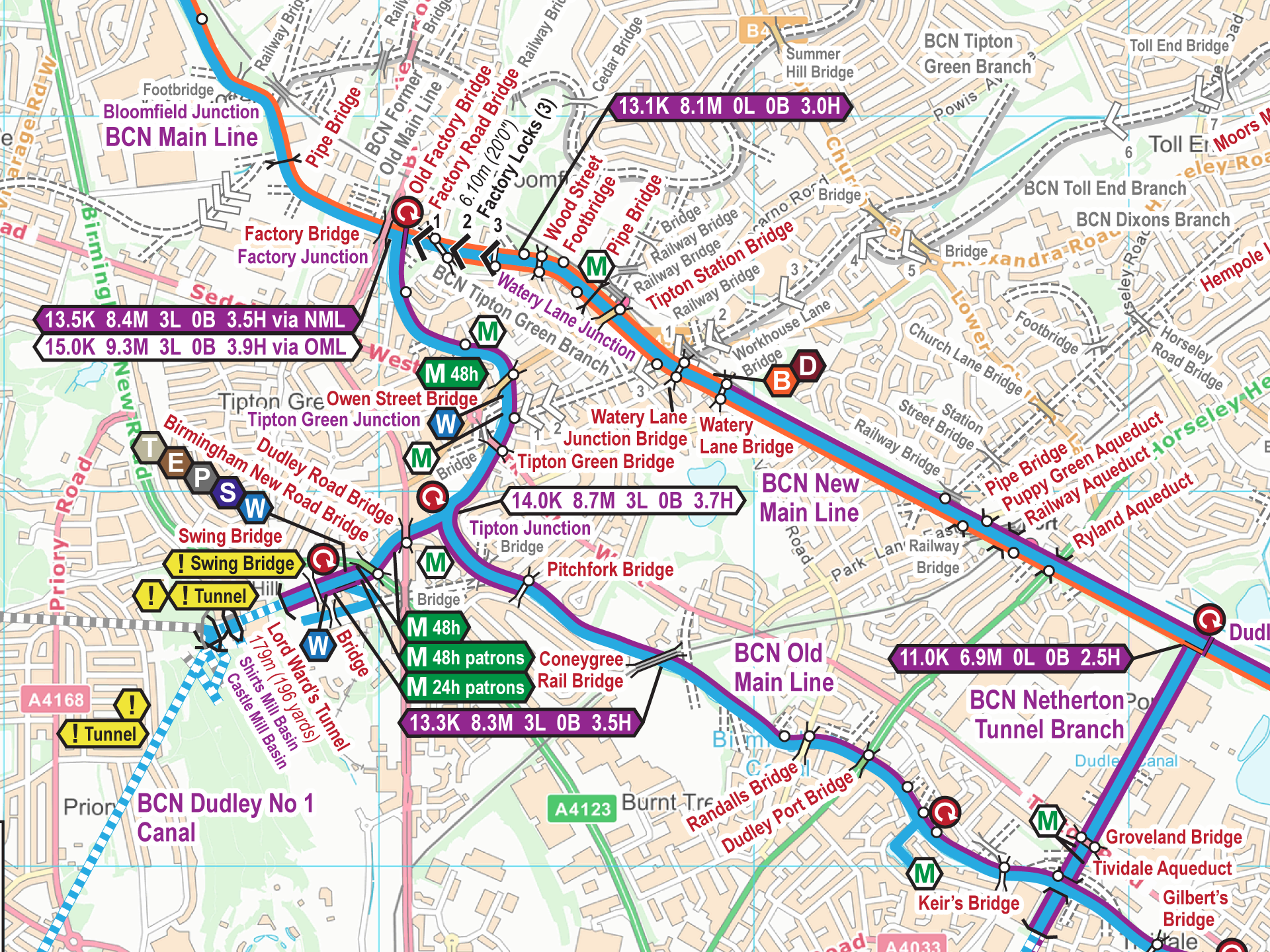
Map Updates – Spring 2026
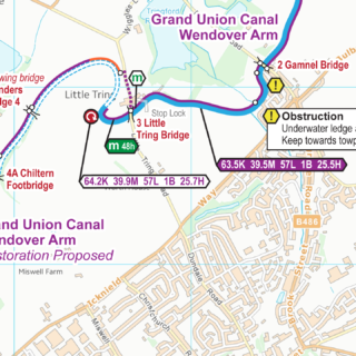
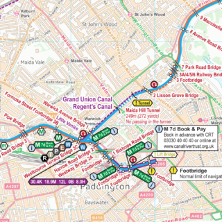
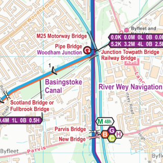
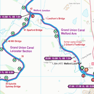
I am pleased to say the Spring 2026 updates for my maps are are now available.
Quarterly map updates mean you not only start with an up to date map but you can keep them up to date too.
![]()
Maps and DVDs for the Waterways of Britain
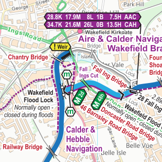
I am pleased to say the Summer 2026 updates for my maps are are now available.
Quarterly map updates mean you not only start with an up to date map but you can keep them up to date too.
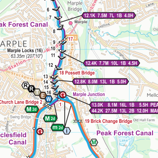
I am pleased to say the Spring 2026 updates for my maps are are now available.
Quarterly map updates mean you not only start with an up to date map but you can keep them up to date too.
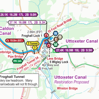
I am pleased to say the Winter 2025/26 updates for my maps are are now available.
Quarterly map updates mean you not only start with an up to date map but you can keep them up to date too.
I am pleased to say the Autumn 2025 updates for my maps are are now available.
Quarterly map updates mean you not only start with an up to date map but you can keep them up to date too.
I am pleased to say the Summer 2025 updates for my maps are are now available.
Quarterly map updates mean you not only start with an up to date map but you can keep them up to date too.
I am pleased to say the map updates for my maps for May2025 are now available.
All these quarterly map updates mean you not only start with an up to date map but you can keep them up to date too.
I am pleased to say the monthly map updates for my maps for April 2025 are now available.
All these monthly map updates mean you not only start with an up to date map but you can keep them up to date too.
I am pleased to say the monthly map updates for my maps for March 2025 are now available.
All these monthly map updates mean you not only start with an up to date map but you can keep them up to date too.
I am pleased to say the monthly map updates for my maps for February 2025 are now available.
All these monthly map updates mean you not only start with an up to date map but you can keep them up to date too.
I am pleased to say the monthly map updates for my maps for January 2025 are now available.
All these monthly map updates mean you not only start with an up to date map but you can keep them up to date too.
I am pleased to say the monthly map updates for my maps for December 2024 are now available.
All these monthly map updates mean you not only start with an up to date map but you can keep them up to date too.
I am pleased to say the monthly map updates for my maps for November 2024 are now available.
All these monthly map updates mean you not only start with an up to date map but you can keep them up to date too.
I am pleased to say the monthly map updates for my maps for October 2024 are now available.
All these monthly map updates mean you not only start with an up to date map but you can keep them up to date too.
I am pleased to say the monthly map updates for my maps for September 2024 are now available.
All these monthly map updates mean you not only start with an up to date map but you can keep them up to date too.
I am pleased to say the monthly map updates for my maps for August 2024 are now available.
All these monthly map updates mean you not only start with an up to date map but you can keep them up to date too.
I am pleased to say the monthly map updates for my maps for July 2024 are now available.
All these monthly map updates mean you not only start with an up to date map but you can keep them up to date too.
I am pleased to say the monthly map updates for my maps for June 2024 are now available.
All these monthly map updates mean you not only start with an up to date map but you can keep them up to date too.
I am pleased to say the monthly map updates for my maps for May 2024 are now available.
All these monthly map updates mean you not only start with an up to date map but you can keep them up to date too.
I am pleased to say the monthly map updates for my maps for March 2024 are now available.
All these monthly map updates mean you not only start with an up to date map but you can keep them up to date too.
I am pleased to say the monthly map updates for my maps for March 2024 are now available.
All these monthly map updates mean you not only start with an up to date map but you can keep them up to date too.
I am pleased to say the monthly map updates for my maps for February 2024 are now available.
All these monthly map updates mean you not only start with an up to date map but you can keep them up to date too.
I am pleased to say the monthly map updates for my maps for January 2024 are now available.
All these monthly map updates mean you not only start with an up to date map but you can keep them up to date too.
I am pleased to say the monthly map updates for my maps for December 2023 are now available.
All these monthly map updates mean you not only start with an up to date map but you can keep them up to date too.
I am pleased to say the monthly map updates for my maps for November 2023 are now available.
All these monthly map updates mean you not only start with an up to date map but you can keep them up to date too.
I am pleased to say the monthly map updates for my maps for October 2023 are now available.
All these monthly map updates mean you not only start with an up to date map but you can keep them up to date too.
I am pleased to say the monthly map updates for my maps for September 2023 are now available.
All these monthly map updates mean you not only start with an up to date map but you can keep them up to date too.
I am pleased to say the monthly map updates for my maps for August 2023 are now available.
All these monthly map updates mean you not only start with an up to date map but you can keep them up to date too.
I am pleased to say the monthly map updates for my maps for July 2023 are now available.
All these monthly map updates mean you not only start with an up to date map but you can keep them up to date too.
I am pleased to say the monthly map updates for my maps for June 2023 are now available.
All these monthly map updates mean you not only start with an up to date map but you can keep them up to date too.
I am pleased to say the monthly map updates for my maps for May 2023 are now available.
All these monthly map updates mean you not only start with an up to date map but you can keep them up to date too.
I am pleased to say the monthly map updates for my maps for April 2023 are now available.
All these monthly map updates mean you not only start with an up to date map but you can keep them up to date too.

I am pleased to say the monthly map updates for my maps for March 2023 are now available.
All these monthly map updates mean you not only start with an up to date map but you can keep them up to date too.
I am pleased to say the monthly map updates for my maps for February 2023 are now available.
All these monthly map updates mean you not only start with an up to date map but you can keep them up to date too.
I am pleased to say the monthly map updates for my maps for January 2023 are now available.
All these monthly map updates mean you not only start with an up to date map but you can keep them up to date too.
I am pleased to say the monthly updates for my maps for December 2022 are now available.
All these monthly updates mean you not only start with an up to date map but you can keep them up to date too.
Those maps with changes include:-
I am pleased to say the monthly updates for my maps for November 2022 are now available. All these monthly updates mean you not only start with an up to date map but you...
I am pleased to say the monthly updates for my maps for October 2022 are now available. All these monthly updates mean you not only start with an up to date map but you...
I am pleased to say the monthly updates for my maps for September 2022 are now available. All these monthly updates mean you not only start with an up to date map but you...
I am pleased to say the monthly updates for my maps for August 2022 are now available. All these monthly updates mean you not only start with an up to date map but you...
I am pleased to say the monthly updates for my maps for July 2022 are now available. All these monthly updates mean you not only start with an up to date map but you...
I am pleased to say the monthly updates for my maps for June 2022 are now available. All these monthly updates mean you not only start with an up to date map but you...
Yes, it really is one hundred and twenty five updates for my maps. I am pleased to say the monthly updates for my maps for May 2022 are now available. All these monthly updates...
I am pleased to say the monthly updates for my maps for April 2022 are now available. All these monthly updates mean you not only start with an up to date map but you...
I am pleased to say the monthly updates for my maps for March 2022 are now available.
Those maps with changes include:-
I am pleased to say the monthly updates for my maps for February 2022 are now available. All these monthly updates mean you not only start with an up to date map but you...
I am pleased to say the monthly updates for my maps for January 2022 are now available. All these monthly updates mean you not only start with an up to date map but you...
I am pleased to say the monthly updates for my maps for December 2021 are now available. All these monthly updates mean you not only start with an up to date map but you...
I am pleased to say the monthly updates for my maps for November 2021 are now available. All these monthly updates mean you not only start with an up to date map but you...
I am pleased to say the monthly updates for my maps for October 2021 are now available. All these monthly updates mean you not only start with an up to date map but you...
I am pleased to say the monthly updates for my maps for September 2021 are now available. All these monthly updates mean you not only start with an up to date map but you...
I am pleased to say the monthly updates for my maps for August 2021 are now available. All these monthly updates mean you not only start with an up to date map but you...
I am pleased to say the monthly updates for my maps for July 2021 are now available. All these monthly updates mean you not only start with an up to date map but you...
I am pleased to say the monthly updates for my maps for June 2021 are now available. All these monthly updates mean you not only start with an up to date map but you...
I am pleased to say the monthly updates for my maps for May 2021 are now available. Observant readers may notice the issue number has jumped from 111 to 113. Just after I had...
I am pleased to say the monthly updates for my maps for April 2021 are now available. All these monthly updates mean you not only start with an up to date map but you...
All these monthly updates mean you not only start with an up to date map but you can keep them up to date too. I am pleased to say the monthly updates for my...
I am pleased to say the monthly updates for my maps for February 2021 are now available. All these monthly updates mean you not only start with an up to date map but you...
I am pleased to say the monthly updates for my maps for january 2021 are now available. All these monthly updates mean you not only start with an up to date map but …

Royal Mail are increasing their postage rates from 1st January 2021. I’ve absorbed their annual increases since 2017 but I can’t absord this fourth increase as well. The postage charges vary depending on where...
I am pleased to say the monthly updates for my maps for December 2020 are now available. All these monthly updates mean you not only start with an up to date map but you...
I am pleased to say the monthly updates for my maps for November 2020 are now available. All these monthly updates mean you not only start with an up to date map but you...
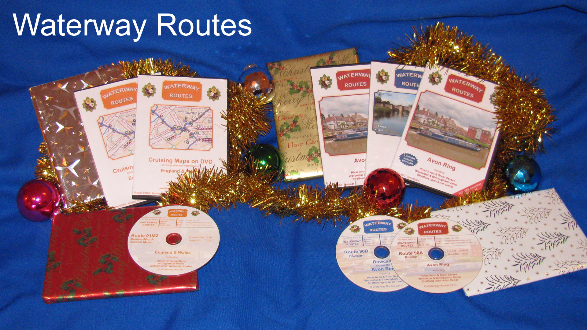
As it’s now November, less than two months until Christmas , I hope you don’t mind me mentioning that word. DVDs make great presents and may be helpful for those planning next year’s holiday,...
I am pleased to say the monthly updates for my maps for October 2020 are now available. All these monthly updates mean you not only start with an up to date map but you...
I am pleased to say the monthly updates for my maps for September 2020 are now available. All these monthly updates mean you not only start with an up to date map but you...

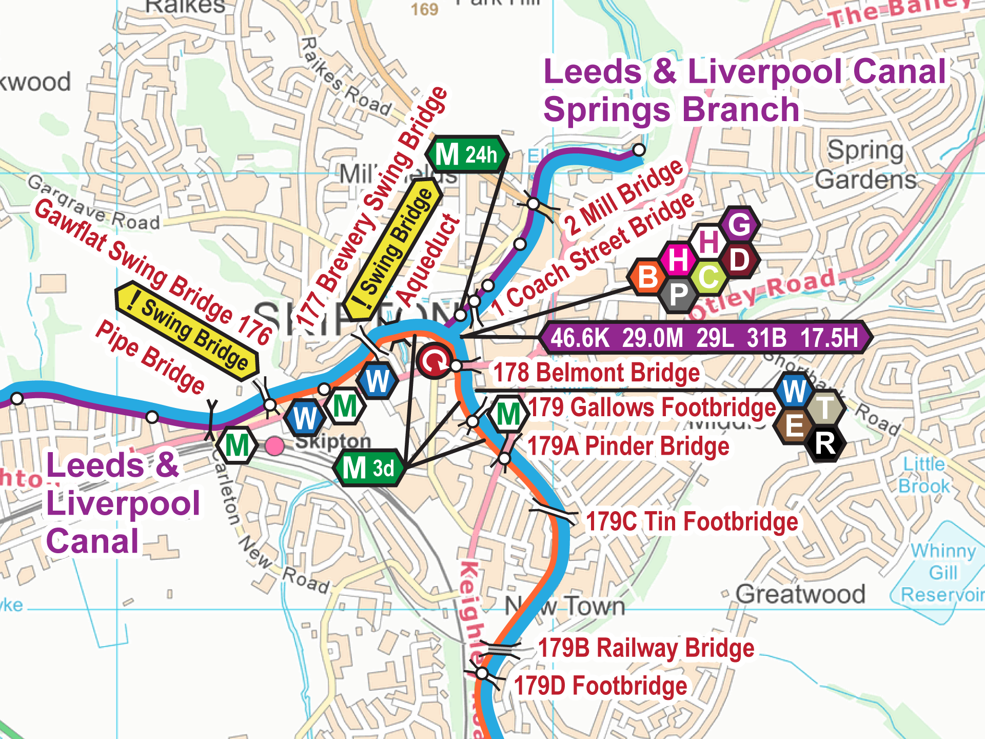
I am pleased to say our Leeds & Liverpool Canal DVDs have just been released. The Leeds & Liverpool Canal DVDs are available in our usual three formats:- Popular – like a television programme...
I am pleased to say the monthly updates for my maps for August 2020 are now available. All these monthly updates mean you not only start with an up to date map but you...
I am pleased to say the monthly updates for my maps for July 2020 are now available. All these monthly updates mean you not only start with an up to date map but you...
I am pleased to say the monthly updates for my maps for June 2020 are now available. All these monthly updates mean you not only start with an up to date map but you...
Yes, this is Issue 100 I have been producing monthly updates for a long time and, on rare occasions, when something important turned up, more than once a month. I am pleased to say...
I am pleased to say the monthly updates for my maps for April 2020 are now available. Yes, we have the 99th monthly issue. Keep watching this blog for news about next months’ update....

The coronavirus is having a significant effect on many aspects of life but… all Waterway Routes services continue as normal. …
I am pleased to say the monthly updates for my maps for March 2020 are now available. All these monthly updates mean you not only start with an up to date map but you...
I am pleased to say the monthly updates for my maps for February 2020 are now available. All these monthly updates mean you not only start with an up to date map but you...
I am pleased to say the monthly updates for my maps for January 2020 are now available. All these monthly updates mean you not only start with an up to date map but you...
I am pleased to say the monthly updates for my maps for December 2019 are now available. All these monthly updates mean you not only start with an up to date map but you...
I am pleased to say the monthly updates for my maps for November 2019 are now available. All these monthly updates mean you not only start with an up to date map but you...
I am pleased to say the monthly updates for my maps for October 2019 are now available. All these monthly updates mean you not only start with an up to date map but you...
I am pleased to say the monthly updates for my maps for September 2019 are now available. All these monthly updates mean you not only start with an up to date map but you...
I am pleased to say the monthly updates for my maps for August 2019 are now available. All these monthly updates mean you not only start with an up to date map but you...
I am pleased to say the monthly updates for my maps for July 2019 are now available. All these monthly updates mean you not only start with an up to date map but you...

We stopped at Knowle Hall Wharf last night so the engine and hot water tank could cool down overnight ready for Ian Taylor to fit a new immersion heater. The old one had stopped...
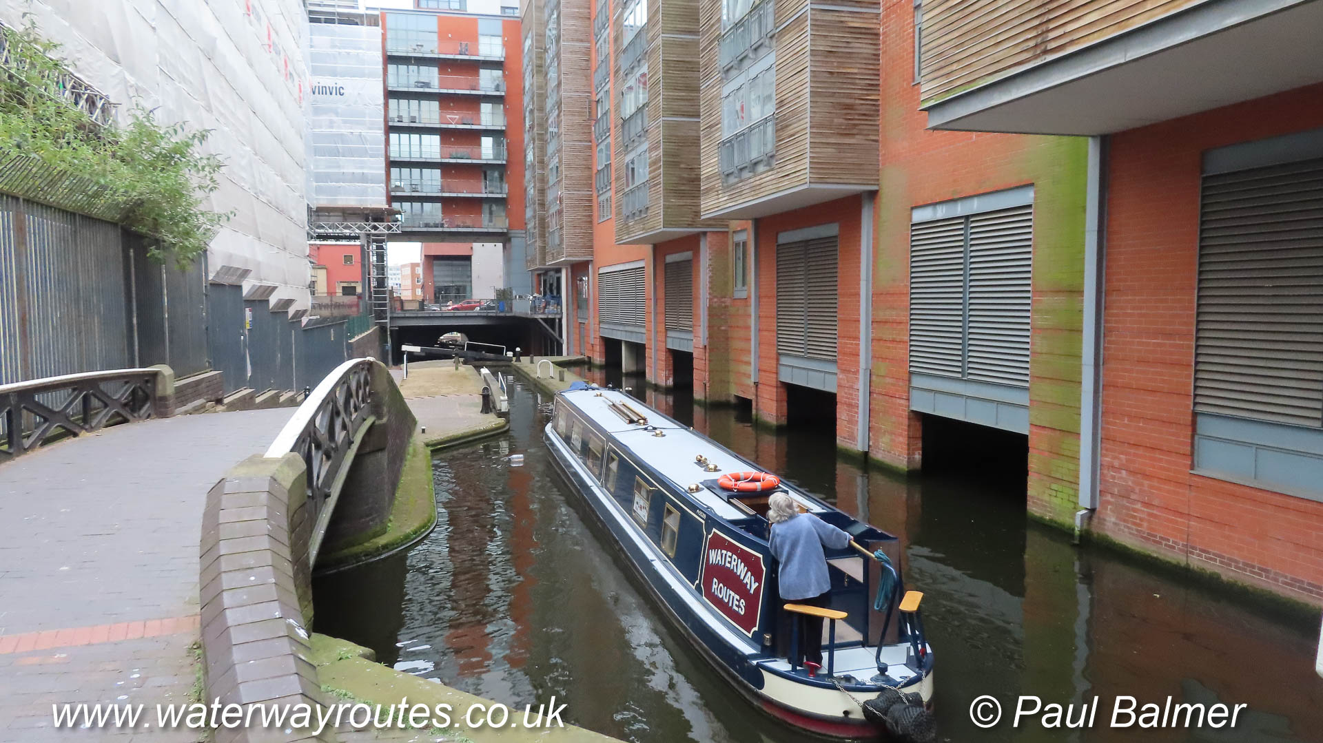
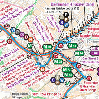
We left Birmingham today, heading for Knowle Hall Wharf. The descent of Farmers Bridge Locks went as planned and we turned right onto the Digbeth Branch of the Birmingham & Fazeley Canal. We went...
We’re on board our Waterway Routes narrowboat ready to go tomorrow. We are heading south, towards London, down the Grand Union Canal. We’ll be starting down Farmers Bridge Locks around 09:00 tomorrow (Monday) morning...
I am pleased to say the monthly updates for my maps for June 2019 are now available.
All these monthly updates mean you not only start with an up to date map but you can keep them up to date too.
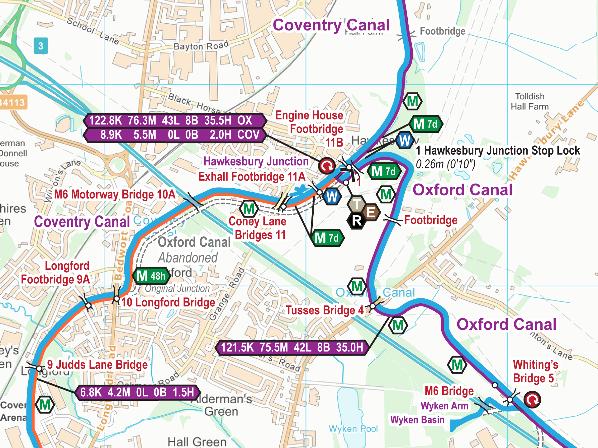
There is an updated Ordnance Survey (OS) Background Map this time so every map has changed this month, even those without any specific changes to the waterway information. Those with changes to the waterway information are:-
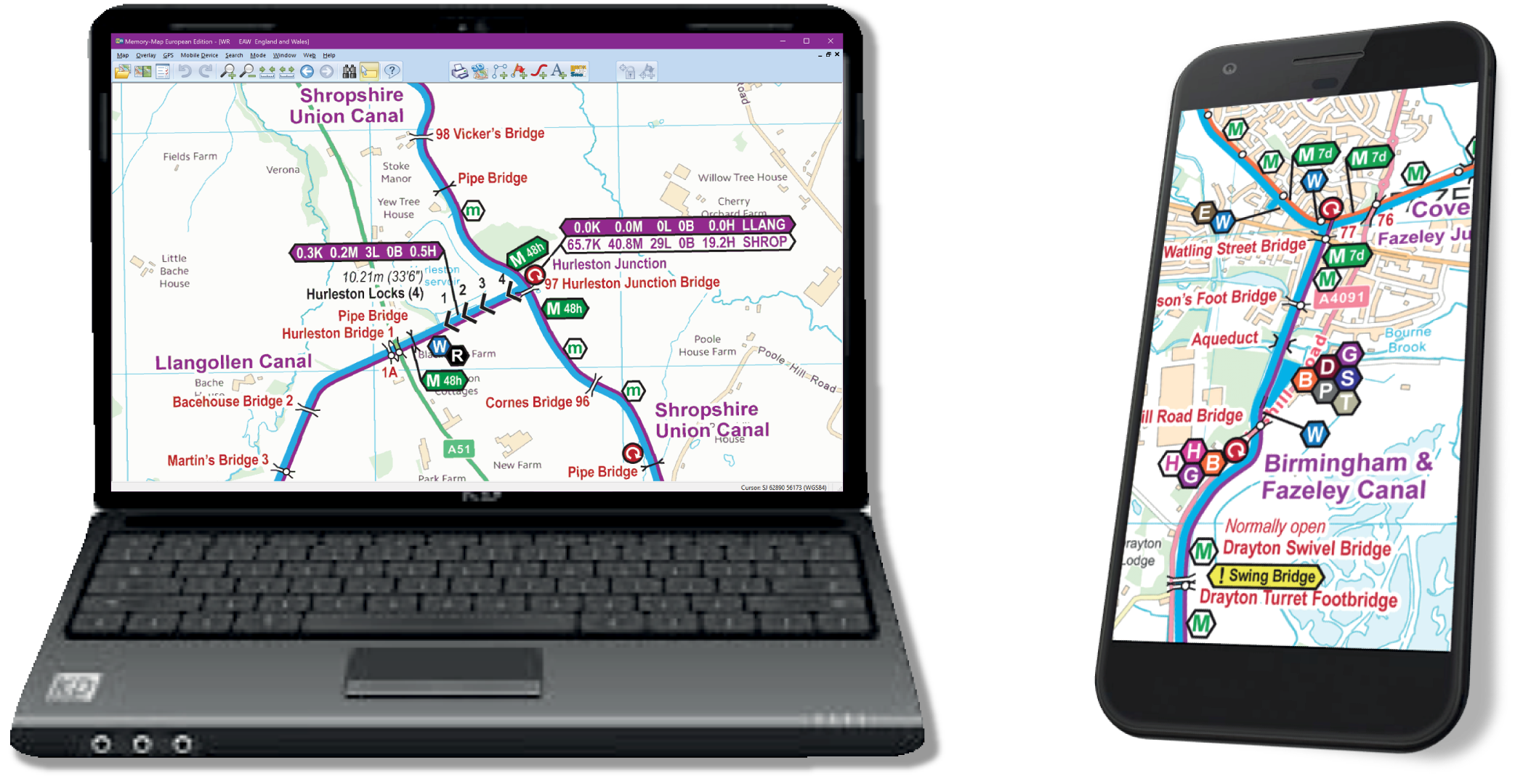
Actually 1,006 different pages of A4 mapping make up my England & Wales maps in Acrobat (pdf) format. And the same 1,006 different pages joined into one large continuously scrollable and zoomable map for use...
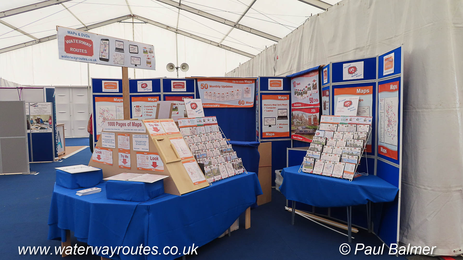
For the first time ever, we’ve been setting up our stand for the Crick Boat Show on a Thursday. This year there is a “Trade and Preview” day on Friday so we’ve all set...
Actually 102 maps to choose from in my extensive range covering all the connected waterways, and a few more too. Over 1,000 pages of maps are available in different ways:-
Actually 54 free maps covering the restoration projects. These mostly have a large volunteer involvement and providing the maps free of charge for these projects helps them a little. Here’s the long list of...
I am pleased to say the monthly updates for my maps for May 2019 are now available. All these monthly updates mean you not only start with an up to date map but you...
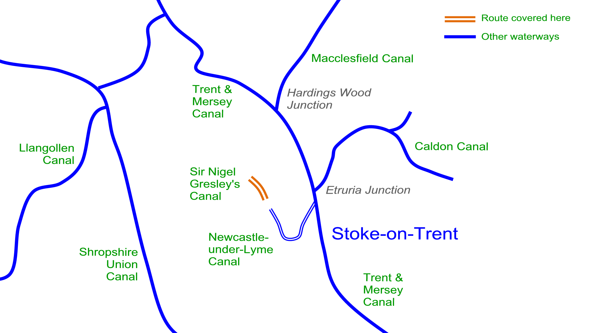
Yet another free map added to my website. This one covers Sir Nigel Gresley’s Canal. That’s just to the north of Newcastle-under-Lyme and it’s not connected to any other canals, although it comes within...
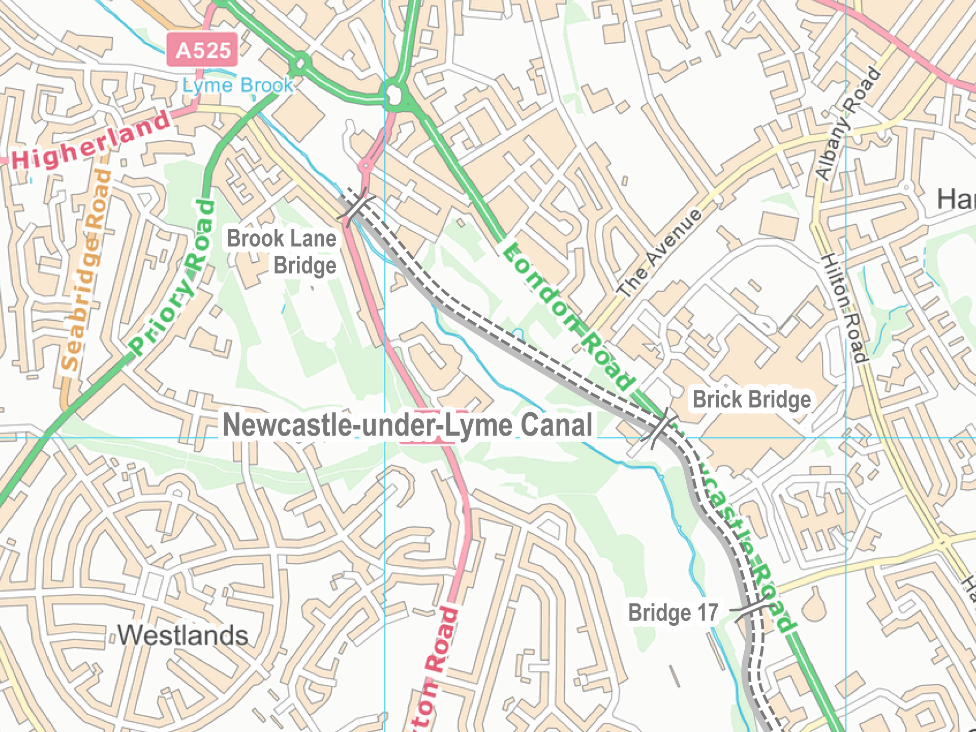
I’ve recently added maps for another abandoned canal to the range of free maps for restoration projects and abandoned canals. The canal once linked to the Trent and Mersey Canal below Stoke Locks, near...
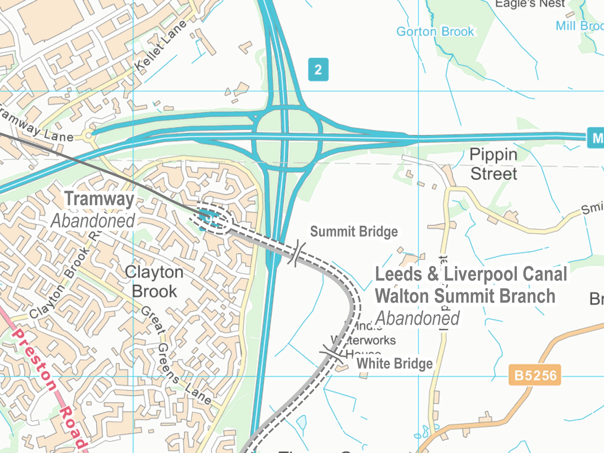
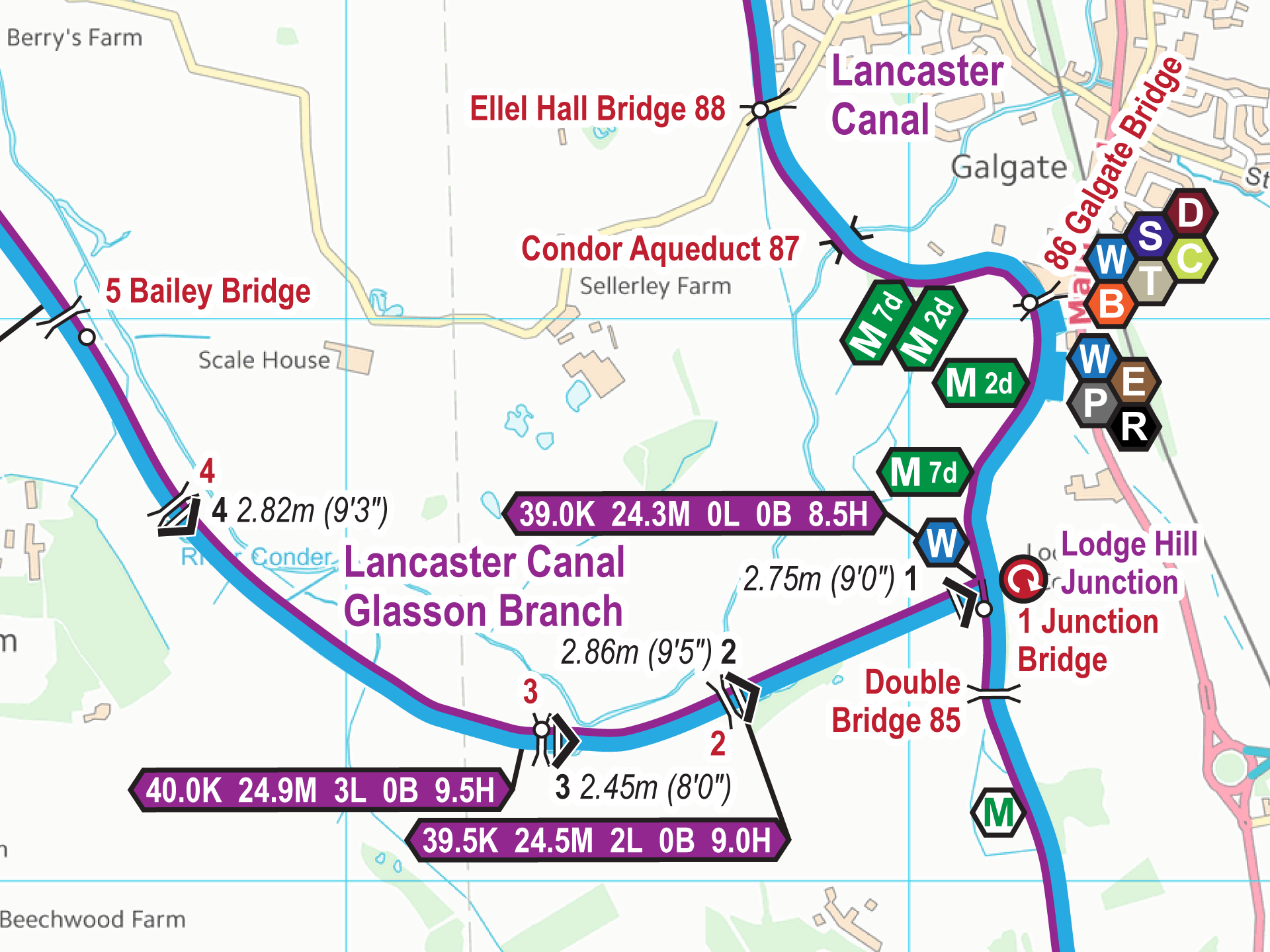
Ths south end of the Lancaster Canal was once linked to what we now call the Leeds & Liverpool Canal at the foot of Johnson’s Hillock Locks. The link was by means of a...
I am pleased to say the monthly updates for my maps for April 2019 are now available. All these monthly updates mean you not only start with an up to date map but you...
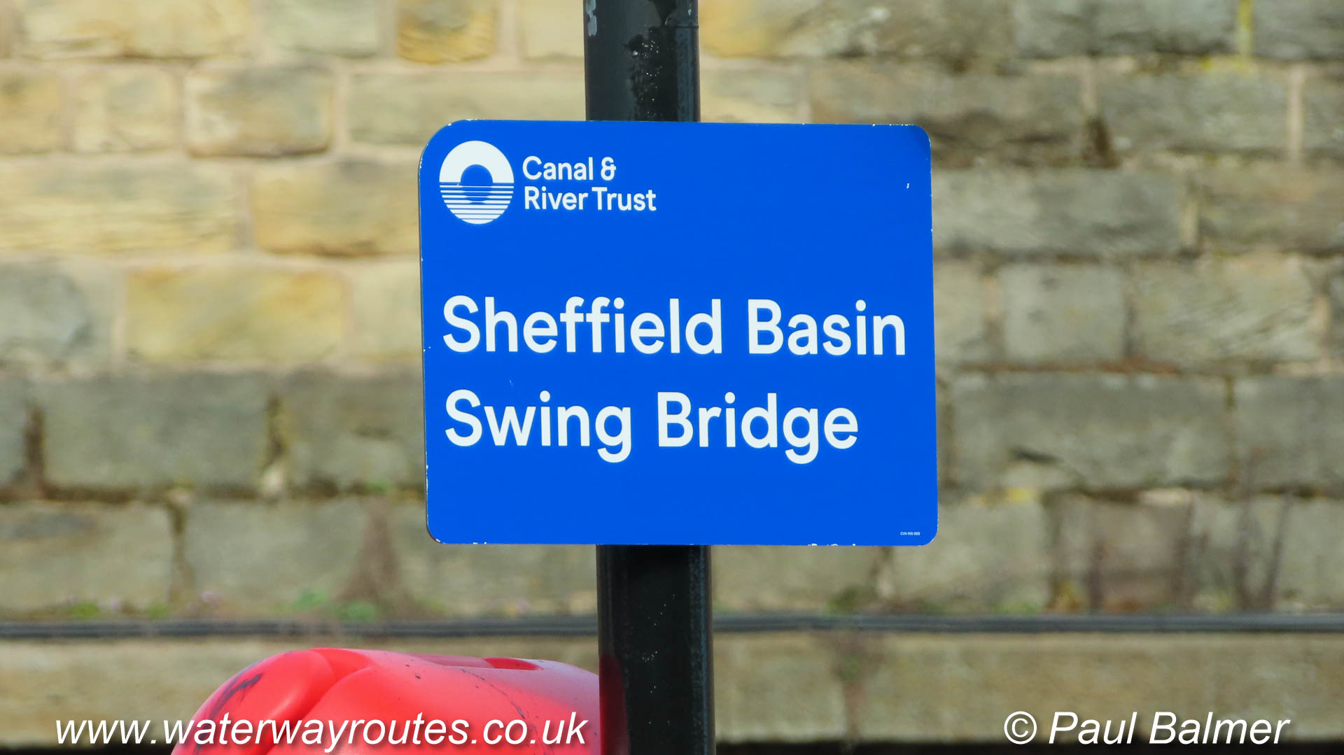
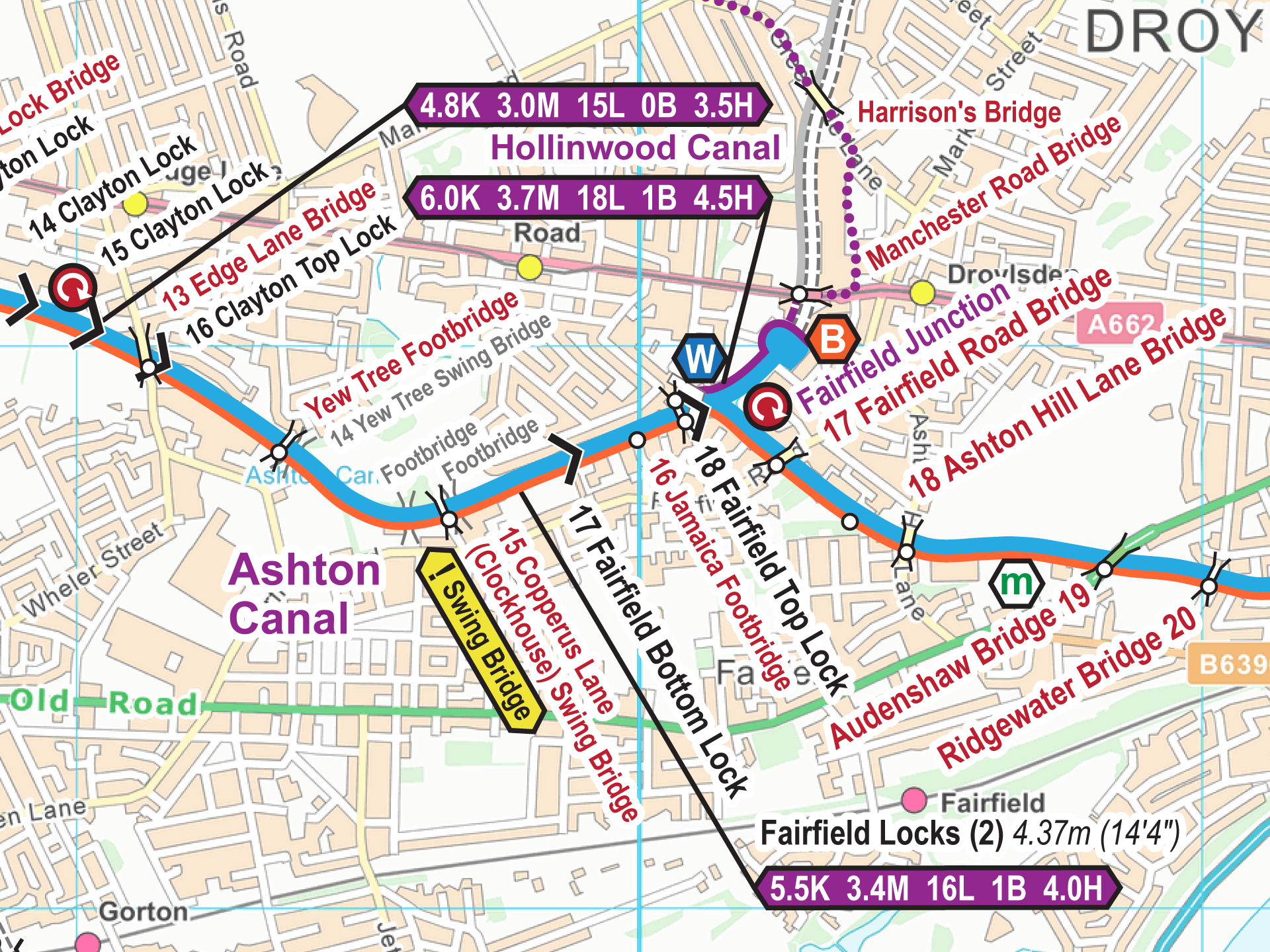
Sarah, owner of historic narrowboat Chertsey (No 130), blogged last week about the curious numbering of the bridges along the Sheffield & Tinsley Canal with new blue signs. This canal was reaching the top of my list of waterways to be walked or cycled to re-check the map data so an exchange of emails resulted in us walking together from …
I am pleased to say the monthly updates for my maps for March 2019 are now available. All these monthly updates mean you not only start with an up to date map but you...
The latest maps in the Waterway Routes series of maps cover a group of waterways in the South West. The first two are canals, at least part navigable, with several more waterways included too:...
I am pleased to say monthly updates for my maps for February 2019 are now available. All these monthly updates mean you not only start with an up to date map but you can...
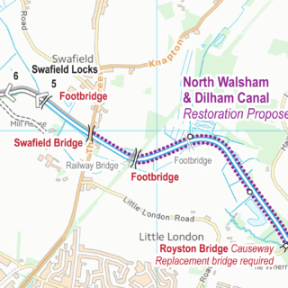
The North Walsham & Dilham Canal was opened in 1826 and ran from Antingham to join the River Ant at Smallburgh. Restoration has started with proposals to restore the rest of the route. I...
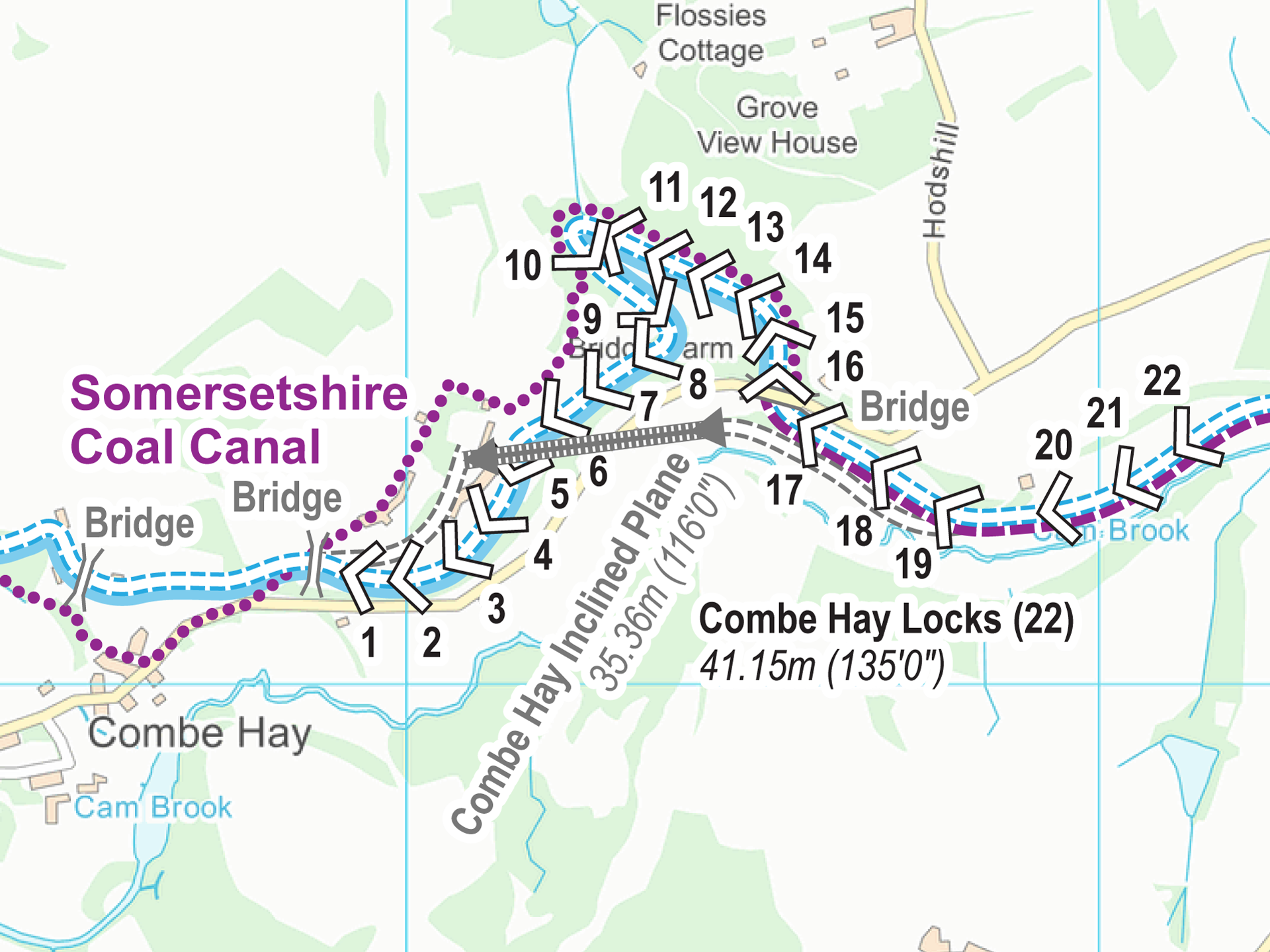
The Somersetshire Coal Canal was opened around 1800 and ran from Paulton to join the Kennet & Avon Canal near Bath. The Radstock Branch ran from Radstock but was only joined to the main...
I am pleased to say monthly updates for my maps for January 2019 are now available. All these monthly updates mean you not only start with an up to date map but you can keep...
I am pleased to say monthly updates for my maps for December 2018 are now available. All these monthly updates mean you not only start with an up to date map but you can keep...
 Trent & Mersey Canal Map for Download
by Elaine Case
Trent & Mersey Canal Map for Download
by Elaine Case
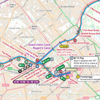
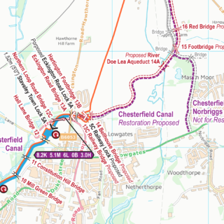
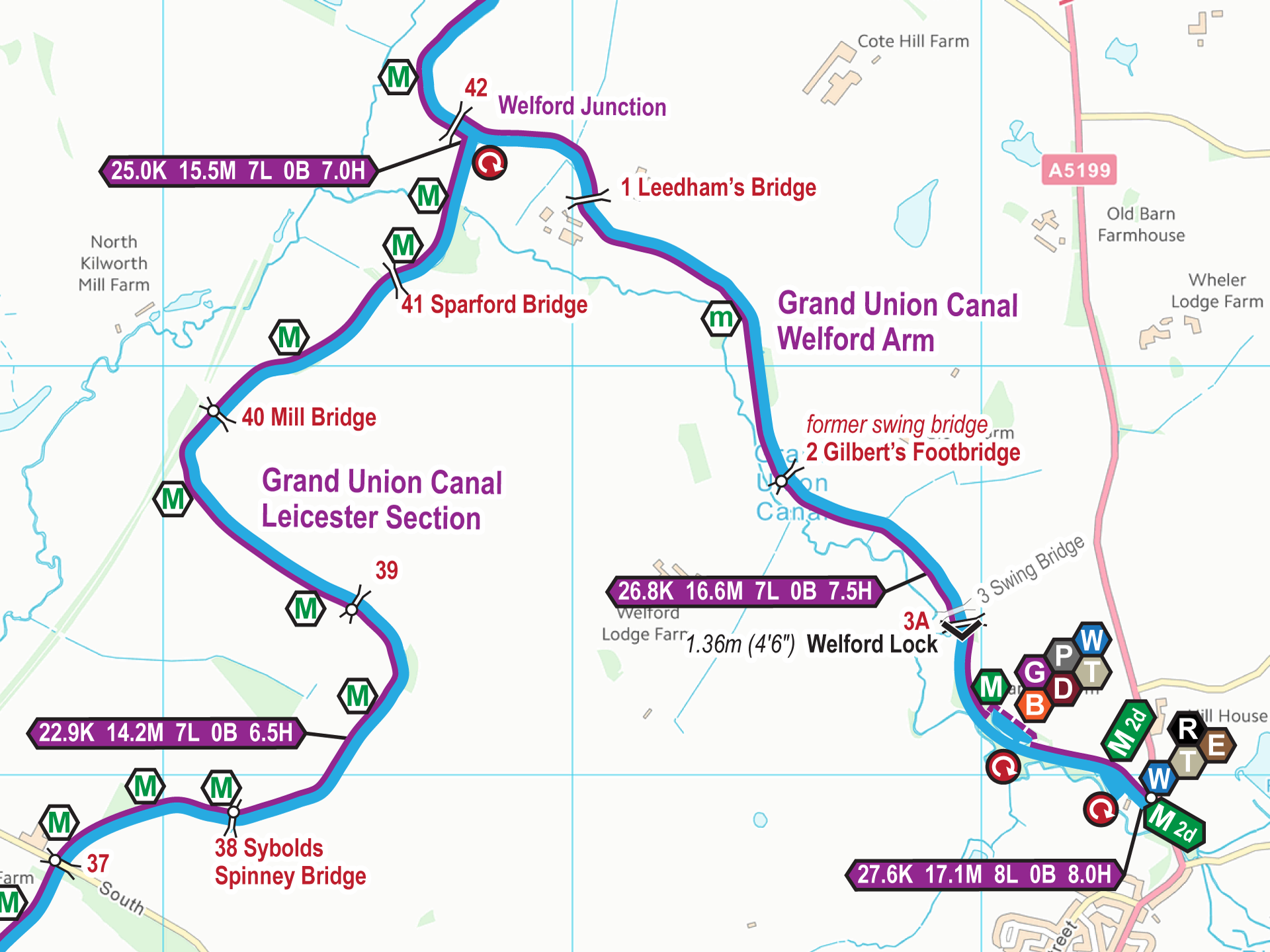
 England & Wales Waterway Map for Download
by Rudolf Bischof
England & Wales Waterway Map for Download
by Chris Hutchins
England & Wales Waterway Map for Download
by Rudolf Bischof
England & Wales Waterway Map for Download
by Chris Hutchins
 Cheshire Ring Map for Download
by Elaine
England & Wales Waterway Map for Download
by Tony Paxton
Cheshire Ring Map for Download
by Elaine
England & Wales Waterway Map for Download
by Tony Paxton
 RSS Blog Feed
Recent Comments